Collaboration Among Counties Improves Regional Vulnerability Assessments
Stressors and impacts
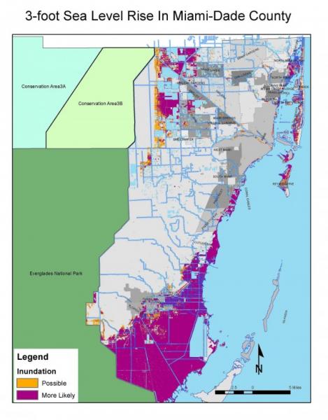
Southeast Florida is particularly susceptible to inundation from sea level rise: the region's high population density combined with its proximity to a coastline and low elevation mean that people and property across the region are at risk for coastal flooding. Residents already experience flooding during heavy rain, coastal storms, and high tide events. They're also seeing saltwater intrusion into freshwater aquifers. Leaders in four counties recognized an urgent need to determine the most vulnerable portions of the region so they could develop a coordinated response. However, initial efforts to create a regional plan revealed an obstacle—inconsistent mapping methods among the counties complicated the task of compiling a single region-wide analysis.
New skills enable collaboration
In April 2010, stakeholders from four counties in Southeast Florida—Monroe, Miami-Dade, Broward, and Palm Beach—participated in a workshop to develop a unified set of methods and criteria for creating sea level inundation maps. Staff from NOAA’s Office for Coastal Management and NOAA’s Center for Operational Oceanographic Products and Services facilitated the two-day technical workshop. Participants, including local GIS practitioners and staff from the South Florida Water Management District, local universities, and federal agencies, defined local challenges, learned state-of-the-art inundation mapping methods, and agreed upon a consistent set of methods to map sea level rise. Participants eventually applied their new skills and techniques to develop a regional vulnerability assessment for scenarios of one-, two-, and three-feet of sea level rise.
Vulnerabilities point to the need for continued cooperation
The regional assessment revealed vulnerabilities to inundation and flooding in all four counties. Monroe County, which includes the Florida Keys, faces the greatest potential impacts from sea level rise, in part because most of its land is near a shoreline. In the scenario with one foot of sea level rise, 68 percent of Monroe County’s unincorporated land mass was deemed vulnerable to inundation. The same scenario showed 75 percent of Monroe County's hospitals, 65 percent of its schools, and 71 percent of its emergency shelters would be flooded. Potential impacts of one foot of sea level rise are smaller on Florida's mainland, but the other counties showed similar vulnerabilities for the scenario with three feet of sea level rise. Values of at-risk property across the region are quite dramatic in some locations and vary greatly depending on the magnitude of sea level rise, ranging from over $4 billion in the one-foot scenario to over $31 billion in the three-foot scenario.
The four counties are now able to identify vulnerable locations and evaluate regional-scale solutions to increase resilience. Continued cooperation between the counties, municipalities, and local, state, and federal agencies will be critical in establishing policies to manage inundation risks.
Adapted from NOAA Digital Coast, "Developing Consistent Methods for Mapping Sea Level Rise in Southeast Florida."
Imagery © 2014 Google, Data SIO, NOAA, U.S. Navy, NGA, GEBCO, Map data ©2014 Google
For more information about the Southeast Florida Regional Climate Change Compact, check out this Georgetown Climate Center report.


